The mills route
Discover
Places of interest


Beschreibung
The starting point of this 9 km long route is Cueves del Agua village, where a signposted steep trail leads up to Monte Moru, the summit of your walk, beside Tresmonte village. Past 4 km you’ll get to Tresmonte road where a sign indicates Tresmonte location. From the top of the road a magnificent bird’s-eye view over the whole district is available. Then, continuing to your left to the south, down along the steep road, you will finally get to Tresmonte, the highest village in the municipality.
A homage plaque there remembers that this village was the birthplace of Manuel Fernández Juncos. He was a renowned statesman and writer in Puerto Rico, and main defender and promoter of the Spanish language use in the island, after it came under the military control of the USA, in 1898.
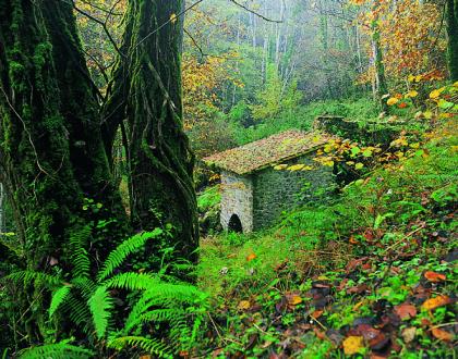
Now, the Cantabrian mixed forest at your feet is the second part of the route, and the place where the watermills stand. So, you’ll have to abandon Tresmonte village to go down back to Cueves del Agua, following the tinkling stream’s course inside this deep forest area. The waters of Tresmonte stream are the ones that historically fed the lined group of ancient mills you’ll be finding next.
Countryside watermills were mostly used to obtain corn flour, being corn the essential nourishment of the region for centuries. The mechanism of this antique invention based on conducing water to a deep pressure tank whose bottom part left water pour strongly. That strength of this pressured water made a water wheel and a vertical axle spin. Above the axle, two heavy discs of stone –one fixed one spinning- milled the grain.
Finally, at the end of Tresmonte stream, outside the forest, you’ll be back to Cueves village, beside the Sella river’s course.
Moderate level hiking trail inside a Cantabrian forest where some restored structures of traditional watermills can be seen. Length: 9 km.
The starting point of this 9 km long route is Cueves del Agua village, where a signposted steep trail leads up to Monte Moru, the summit of your walk, beside Tresmonte village. Past 4 km you’ll get to Tresmonte road where a sign indicates Tresmonte location. From the top of the road a magnificent bird’s-eye view over the whole district is available. Then, continuing to your left to the south, down along the steep road, you will finally get to Tresmonte, the highest village in the municipality.
A homage plaque there remembers that this village was the birthplace of Manuel Fernández Juncos. He was a renowned statesman and writer in Puerto Rico, and main defender and promoter of the Spanish language use in the island, after it came under the military control of the USA, in 1898.
Now, the Cantabrian mixed forest at your feet is the second part of the route, and the place where the watermills stand. So, you’ll have to abandon Tresmonte village to go down back to Cueves del Agua, following the tinkling stream’s course inside this deep forest area. The waters of Tresmonte stream are the ones that historically fed the lined group of ancient mills you’ll be finding next.
Countryside watermills were mostly used to obtain corn flour, being corn the essential nourishment of the region for centuries. The mechanism of this antique invention based on conducing water to a deep pressure tank whose bottom part left water pour strongly. That strength of this pressured water made a water wheel and a vertical axle spin. Above the axle, two heavy discs of stone –one fixed one spinning- milled the grain.
Finally, at the end of Tresmonte stream, outside the forest, you’ll be back to Cueves village, beside the Sella river’s course.